THE FLEETI BLOG
Geofencing in fleet management: what are virtual zones used for?
Geofencing draws virtual zones around your sites and alerts you when a vehicle enters or leaves, to secure your fleet and track on-site activity.

Co-founder and Chairman
Last updated
AT A GLANCE
The topic: geofencing, which draws virtual zones around a company’s sites (depot, construction site, client site) and triggers an alert when a fleet vehicle enters or leaves them.
Key uses: defining areas of activity, tracking the fleet live, optimising journeys, notifying clients of delays, detecting the theft of vehicles and machinery, and proving time spent on site for invoicing.
With Fleeti: Fleeti, the SaaS fleet management and telematics software founded in 2020, builds geofencing into vehicle and machinery tracking, with zone entry and exit alerts. Its client Sik Yuen uses it to track the time spent at its own clients’ premises. Fleeti has more than 1,000 clients and 40,000 connected vehicles and machines, with local teams in 7 countries across France and Africa.
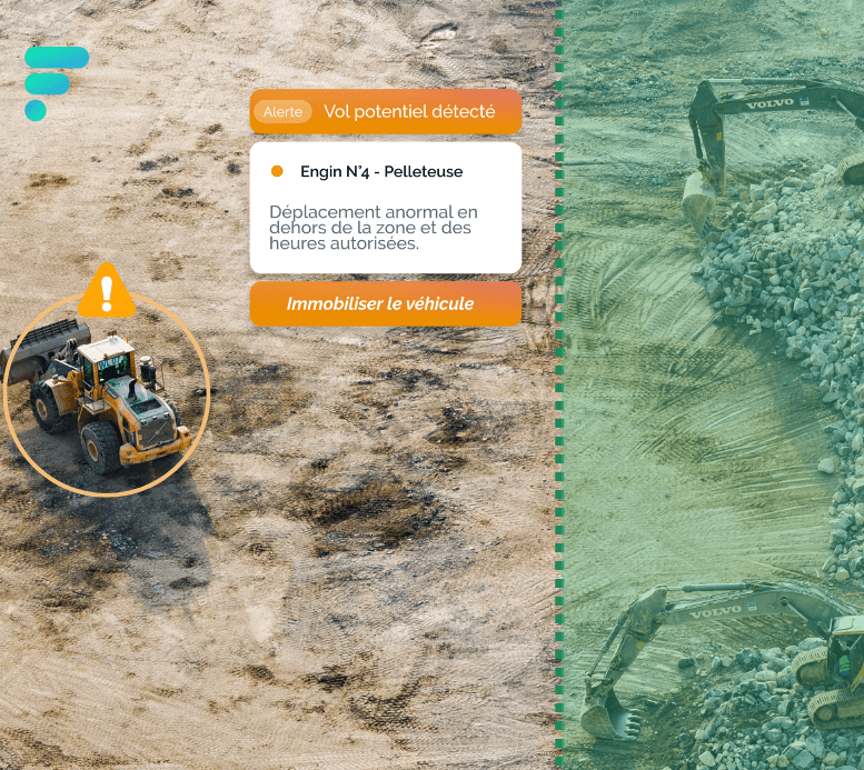
Geofencing uses GPS to draw virtual geographic boundaries, known as geofences or virtual fences. When a fleet vehicle enters or leaves one of these zones, a predefined action is triggered: an alert, a notification or a record of the time it passed through.
A geofence can surround the company’s head office, client sites, a secure area, a field or even an entire city. This guide explains how geofencing works, what it brings to fleet management and how to use it day to day.
How does geofencing work in a vehicle fleet?
Geofencing continuously cross-checks the GPS position of each vehicle against the zones drawn on a map in the fleet management software. As soon as a vehicle crosses the boundary of a geofence, the software records the event and notifies the fleet manager with an alert or a push notification, without them having to watch the map.
Each zone corresponds to a location that matters to the business: depot, construction site, client site or an area where vehicles must not go. The fleet manager then chooses which events to track, such as entry, exit, length of stay or movement outside scheduled hours. Everything relies on the live location of each vehicle and piece of machinery. In Fleeti, a geofence can be a circle, a polygon that follows the outline of a site or a corridor along a route, and each zone has its own alerts, sent by email, text message or mobile notification, as detailed on the Fleeti GPS tracking and geofencing page.
What are the benefits of geofencing for fleet management?
Geofencing brings six benefits to fleet management: defining areas of activity, tracking the fleet live, optimising journeys, improving customer satisfaction, preventing vehicle theft and simplifying invoicing. They all rest on the same principle: being informed automatically when a vehicle enters or leaves a zone.
Defining geographic zones: set precise zones where your vehicles and equipment should be, so that you can monitor them.
Live fleet tracking: analyse your vehicles’ activity on site, such as the duration of journeys and stops, the frequency and number of stops or visits, and the times and duration of jobs (working time).
Journey optimisation: assess how relevant your employees’ delivery and driving routes are to detect inefficiencies, then reduce the distance covered, journey times and fuel consumption.
Customer satisfaction: receive a push notification if one of your employees is running late for a client, so you can quickly let the client know.
Preventing vehicle theft: get a real-time alert if one of your vehicles is moved outside the predefined zones.
Simpler invoicing: base your invoicing on the report of hours your teams spent on site. Geofencing proves that a job was carried out by showing its date and duration.
How does geofencing help prevent the theft of vehicles and machinery?
Geofencing prevents theft by flagging in real time any vehicle or piece of machinery that leaves its authorised zone. A machine leaving a construction site at night or a vehicle leaving the depot outside scheduled hours triggers an alert: the fleet manager can check the situation and react before the vehicle has gone far.
This zone-based monitoring is particularly useful for securing construction sites, where machinery stays on site outside working hours. It forms part of an anti-theft system for vehicles and machinery, which our guide complements by explaining how to immobilise a machine remotely.
Rental companies also use it to control cross-border use: an alert flags any vehicle that leaves the country or region set out in the contract. This use case is detailed on our page dedicated to fleet management for vehicle rental companies.
How does geofencing help prove time spent at client sites?
Geofencing automatically records the arrival and departure time of each vehicle at a client site. The company thus has a reliable report of hours on site, which proves that a job was carried out, along with its date and duration. This report is used to invoice the client and to track the actual number of visits per team.
Field service companies use it to track their teams without any manual data entry. Read the testimonial from our client Sik Yuen, which uses geofences and digital forms every day:
“With Fleeti, we optimise the monitoring of our operations. Their geolocated form solution allows us to effectively monitor the actual number of client visits for each member of our team, ensuring impeccable customer service. The geolocated forms have also enabled us to build up our client database on the platform and therefore to create geofences, which in turn let us track the time spent at our clients’ premises. Fleeti is a very responsive and attentive partner, making the collaboration efficient and enjoyable.”
Why integrate geofencing into fleet management software?
Integrated into telematics software such as Fleeti, geofencing gives you complete visibility over your operations and strengthens both security and transparency within your organisation, a direct lever for securing field operations. Zone alerts can then be read alongside the rest of your fleet data: journeys, stops, fuel consumption and job times.
Geofencing is just one of the uses of vehicle tracking: discover the five benefits of vehicle tracking for businesses. If your zones are also used to monitor employees’ work, check the legal framework for employee tracking beforehand.
What is geofencing in fleet management?
Geofencing means drawing virtual zones, also known as virtual fences, on a map around a depot, a construction site or a client site. The vehicle’s GPS triggers an alert when it enters or leaves the zone. The fleet manager can thus monitor vehicle use, prevent theft and measure time spent on site.